| |
|
|
Beach erosion caused by CEMEX sand mining in Marina by Ed Thornton 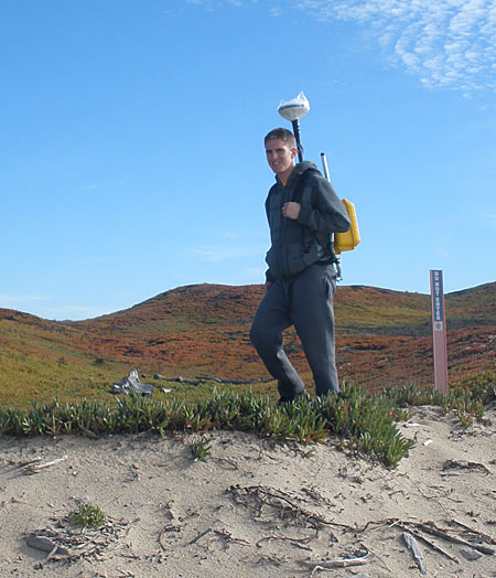 My grandson Nicholas Thornton surveying the dune top edge with precision GPS in his backpack. My grandson Nicholas Thornton surveying the dune top edge with precision GPS in his backpack.The most erosive shoreline on average in all of California is the southern Monterey shoreline from Wharf II in Monterey to the Salinas River (Hapke et.al., 2006). The shoreline is eroding at about 1 foot per year in Monterey, 3 feet in Sand City and more than 6 feet per year in Marina. A region sediment management plan by funded by the State of California (PWA, et.al., 2008) concluded that the primary cause of the ongoing erosion is the more than 200,000 cubic yards of sand mined annually by CEMEX (the sand plant visible from the overpass at the north end of Marina). Imagine for the moment that this amount of sand is equivalent to sand being scrapped off the beach and loaded into 7 cubic yard dump trucks that leave the peninsula every 18 minutes, 24/7; this is effectively is what has been happening for the last 50 years! Some might ask, if the primary reason for the most erosive shoreline in California is sand mining, and the beach and shoreline are primary assets for the eco-tourism economy, why is it allowed to continue? Historically, southern Monterey Bay has been the most intensively mined shoreline in the U.S. By 1950 there were five sand mines, 3 in Sand City and 2 in Marina, taking sand directly from the ocean with scrapper dredges. Since these operations mined sand below mean high tide line (MHW), they came under the jurisdiction of the US Army Corps of Engineers (USACE), who closed them by 1990 when they determined that sand mining caused severe coastal erosion. The ongoing mining operation by CEMEX is different, but has the same impact. Starting in 1965, sand has been mined from a large pond just next to the beach using a hydraulic dredge. The dredge pond is above the mean high tide line (by only about a foot or two), and the USACE do not have jurisdiction. Even though the mine within Marina is robbing their beaches of sand, they have no jurisdiction and derive no direct tax revenue. In fact no one claims to have jurisdiction. The pond is refilled each winter by sand washed from the beach over the top of the berm during big storm waves and high tides (and sometimes with the help of bulldozers) taking the sand from the beach. By 1972 when the Coastal Commission came into being, approximately 100,000 cu. yds of sand per year were being mined here. As the other sand mines were closed, the CEMEX mine increased its production to match the total output of all the mines combined. Therefore, even after the closure of the 5 other dredge mines, the total amount of 200,000 cu yds of sand derived from the ocean has remained essential unchanged for the last fifty years. This amount of sand mined closely matches the amount of yearly erosion for all of southern Monterey Bay. The bay is a system where the waves move sand along the shore, and sand removed from one location impacts the entire shoreline. Southern Monterey Bay is characterized by some of the highest dunes in California that extend back almost to Salinas. The dune edge is the shoreward limit of useable land. The location of the dune edge has been measured since 1945 using a combination of stereoscopic photogrammetry, laser altimetry from airplanes and ships (LIDAR), and walking the dune edge with precision GPS. The most recent survey was accomplished in January 2011 by walking the 15 mile dune edge (see photo). The results of this latest survey find that although the average erosion for the entire shoreline has not changed, the maximum erosion rates have shifted to the vicinity of the CEMEX mine in Marina in response to their increased mining amounts. The impact of continued erosion is for the shoreline to move back. This becomes a problem where buildings are near the shoreline or seawalls are on the beach. As the eroding shoreline moves shoreward, the seawalls remain in place until eventually a peninsula is formed with the seawall extending out into the ocean and walkers are no longer be able to walk along the shoreline at these locations (referred to as lateral access). A good example was the Stillwell Hall seawall in Fort Ord, which has been since removed. The two most obvious seawalls are at the Monterey Beach Hotel and Ocean Harbor House Condominiums, where you already cannot walk along the beach in front of the seawalls during winter waves at higher tide. This will occur at all times in the future if things do not change. For those of us who cherish walking Del Monte Beach, this will come at a great loss. The Ventana Chapter sent a letter to the California Coastal Commission January 2009, requesting they require a permit for the increase in the amount of sand mined since the inception of the Coastal Commission in 1972. It is estimated that the yearly amount of sand has doubled since that time based on historical documents. The Coastal Commission has yet to make a decision. References: Philip Williams & Associates, Thornton, E.B., Dugan, J.E. and Halcrow Group, 2008. Coastal Regional Sediment Management Plan for Southern Monterey Bay. AMBAG. http://www.dbw.ca.gov/csmw/pdf/SMontereyBay_CRSMP_3Nov2008.pdf. < back to all issues |
Current CCC Votes Unanimously For Closure of CEMEX Plant July 2017 CCC to Hold CEMEX Plant Hearing at July Meeting June 2017 Marina Is Going Solar! June 2017 Chapter Approves Trust Fund Grant for Coastal Habitat Restoration Project in Marina October 2013 Beach erosion caused by CEMEX sand mining in Marina January 2012 Chapter member appointed to Regional Water Board December 2011 Habitat Trust Fund producing results in Marina December 2009 Marina commits to sustainability August 2008 Getting close to nature is easy in Marina August 2008 Bioretention on Monterey Bay September 2008 Sand Mining on the Monterey Bay September 2008 Freedom of Information Act Request letter regarding CEMEX sand mining plant (132kB pdf) August 2008 Draft - Coastal Regional Sediment Management Plan for Southern Monterey Bay (3.9MB pdf) August 2008 Getting close to nature is easy in Marina August 2008 Club involvement greens up Marina development March 2008 Marina applies to delete section of Coastal Zone designation October 2007 Will Marina's growth be green? October 2007 More money in Marina conservation account October 2007 $230,000 available for dune habitat in Marina June 2007 |
