A Big Basin Saunter
It's Tuesday morning, April 27, after breakfast, and it's raining outside. Earlier, upon awakening after sleeping soundly for a full nine hours, I stretched out my (slightly sore) legs and thought about our wonderful Sunday walk in Big Basin—just two days ago—and how rejuvenating it was. We need those walks! I'm rested and alert, able to think once again. My self- image of being just an old foggy fogey has vanished.
Such a wonderful day it was—the warm sun, the green of the Spring, the flowers and waterfalls, the tiny Winter Wrens with their long complex songs that welcome the Spring. Life begins again. John Muir taught us to treasure such connections with nature, and it seemed just right to honor him on the anniversary of his birth.
Here are some words from Muir, contributed by Ginny Draper, who was with us on our walk:
Fresh beauty opens one's eyes wherever it is really seen, but the very abundance and completeness of the common beauty that besets our steps prevents its being absorbed and appreciated. It is a good thing, therefore, to make short excursions now and then to the bottom of the sea among dulse and coral, or up among the clouds on mountain-tops, or in balloons, or even to creep like worms into dark holes and caverns underground, not only to learn something of what is going on in those out-of-the-way places, but to see better what the sun sees on our return to common every-day beauty.
— John Muir, from
In the Sierra Foot-Hills
It starts with a bus ride
Twenty of us (including ten from outside Santa Cruz County), met at the Metro Station in Santa Cruz to board the 35A bus that would take us all to Big Basin. It's a ride that takes an hour and a quarter. I like to think of it as a transect of Santa Cruz County's geology—from the lowest marine terraces near our coastline, up through the sand parkland habitat that surrounds Scotts Valley, and finally into the quiet redwood forests where the Big Basin lies. It's also a sociological transect—the folks that live near Santa Cruz are different from those who live in Scotts Valley, and they in turn are different from those who live up in the San Lorenzo Valley—so maybe it's the geology that determines, or at least influences, the sociology.
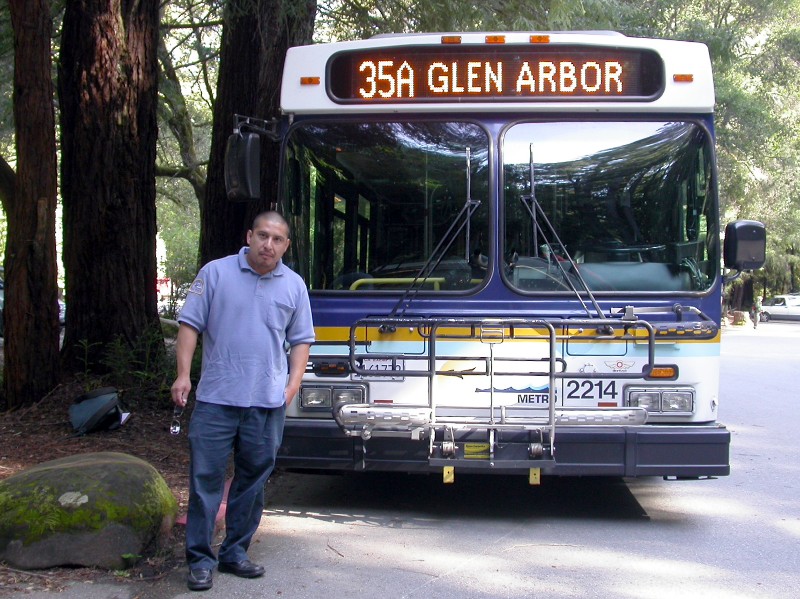
At any rate, at 9:45 am we arrived at the Big Basin Park Headquarters. Here's the bus we came in (ready to return southward), along with Leo, who drove us there. (Note: To enlarge the images on this page, just click on the image.)
Heading toward the Sunset Trail
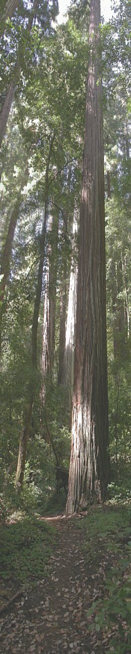
There are several routes that lead down to the coast at the mouth of Waddell Creek. Most folks walk down along the standard “Skyline-to-the-Sea” trail, but my favorite route is via the Sunset Trail, which leads past Big Basin's best waterfalls, has variation in the terrain, and affords a good view or two.
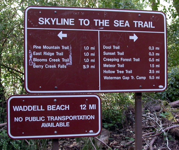
Near the start of the walk, just after crossing the bridge over Opal Creek, there is this misleading sign. There actually is public transportation available at the bottom: The No. 40 bus will pick us up at Waddell Beach at 5:15 pm. We eventually turned right at this sign to head toward the Sunset Trail, but not many yards to the left is a very large old growth redwood that we went to visit.
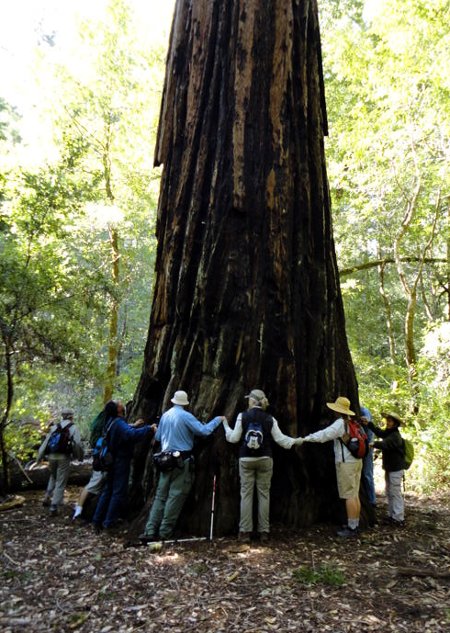
Here we are, paying respects to the tree. It took thirteen of us to stretch around the tree's circumference. However, we loved that tree a little too much. There's a guard rail around the tree, meant to discourage folks from doing what we did. It's not a good idea to compact the soil around the base of the tree, since it tends to prevent the tree from absorbing its needed water and nutrients. Next time I think we'll view it from a distance, and pay our respects with our voices. That tree may live for another thousand years, and we need to give it the chance. The photo is by David Garcia.
As we headed west toward the start of the Sunset Trail, and then on up to what is called the “Middle Ridge”, we were serenaded by the first of several Winter Wrens. The tiny Winter Wren has a marvelously lengthy and complex song. You can listen to one Winter Wren's song by clicking on the left arrow in the bar below:
Just what is the Winter Wren saying? One clue is suggested by my friend and expert birder Todd Newberry. The heart rate of a Winter Wren is typically several hundred beats per minute, roughly eight times that of a human heart, so the speed of its hearing and speaking (and associated comprehension) may be similarly large. So perhaps one way of getting to understand the Winter Wren is to slow down its song to a more human scale, so we can hear what it's saying.
Just to illustrate, here's another song. Could it be some kind of chicken?
What is this second bird saying? To find out, let's try slowing it down:
All right, so let's see what the Winter Wren's song sounds like if we slow it down. Here it is, slowed down by a factor of about eleven:
If I had heard such a beautiful song while walking through the woods I would have immediately fallen in love. Is this how another Winter Wren might feel upon hearing the original song?
Down (and up) the Sunset Trail
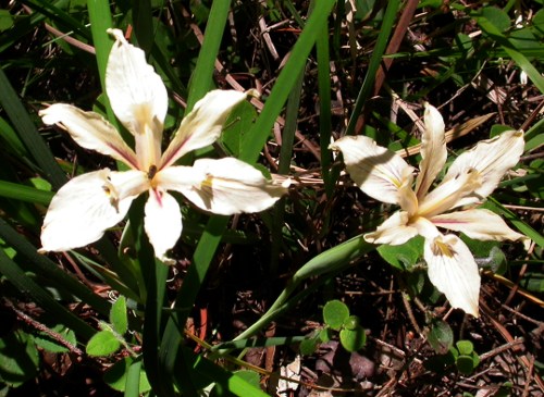
OK, after leaving the Middle Ridge, we wended our way down the Sunset Trail. Along the way, Giancarlo decided to count the banana slugs he saw. By the time we reached our lunch spot, he had already counted eighty-seven slugs. I never would have imagined that there were so many. We also saw several Douglas Irises, like those shown at the left.
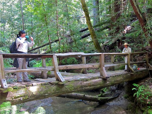
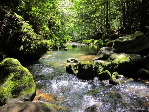
Eventually, around 11:30, we arrived at the West Fork of Waddell Creek, which is crossed by this rough-hewn bridge. On the left is Sandra, and on the right, about to cross the bridge, is her cousin Esperanza. The photo was taken by Bob Schumacker. At this crossing there is also a magnificent stand of Equisetum, or Horsetails, not quite visible in the photograph.
After a short stop for resting at the West Fork bridge, we made our way, first climbing out of the West Fork drainage, and then, eventually, down to meet Berry Creek. On the way we crossed an open area of sandstone, with lots of Knobcone Pines, a few Bush Poppies and chaparral, with some good views. We also passed the trail to the Sunset Camp, which leads upwards a short distance to the campsite. One might think it worth a visit, but it turns out not to be a very attractive campsite, so we continued on down.
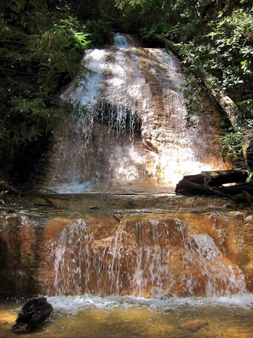
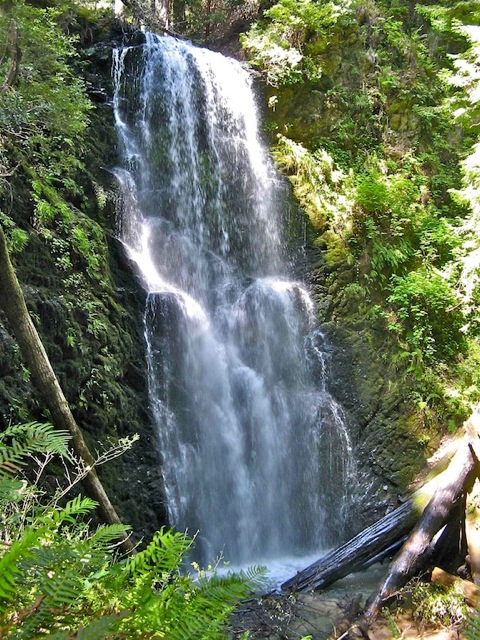
Shortly after 12:30 we arrived at the Golden Cascade on Berry Creek, where we stopped for lunch. Here's what the cascade looks like. It surely lives up to its name. The golden color seems to arise from the color of the underlying rock. This is Bob Schumacker's photograph.
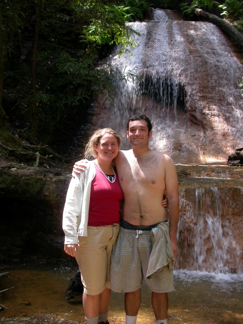
We took our time eating our lunch, with many of us sitting on a nice log in the warm sun, facing the waterfall. While we were there, Giancarlo noticed a newt in the pool below the fall, along with about half a dozen newt egg sacs attached to a stick lying in the water, which he pointed out to us. At the right are Deirdre and Giancarlo. The egg sacs of the newt, not visible in this photo, were in the water just below Deirdre's right hand.
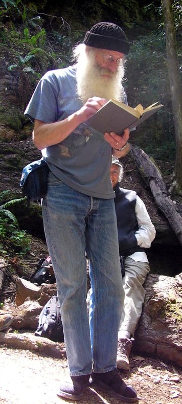
After lunch several of us read aloud some favorite quotes from John Muir's writings. When it got to my turn I read a short excerpt from Muir's “The Story of My Boyhood and Youth”, about his difficult relationship with his father Daniel, and his own avid interest in designing and building (in the wee hours of the morning—cleverly avoiding his father's objections) various machines to perform useful tasks. While I was reading, Esperanza snapped the photograph below.
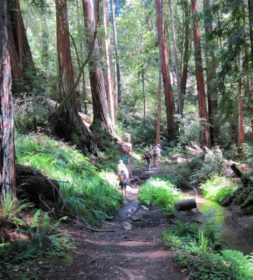
We left our lunch site at about 1:45, and made our way through the redwoods along Berry Creek. One of DJ Goehring's photographs (below, on the right) catches the flavor of the walk. Along the way we saw several Red Clintonias, but they were past their prime, and no longer in full bloom.
After a short distance we arrived at the top of Silver Falls, where the trail descends precariously over rocks right at the lip of the waterfall. Fortunately, there is a cable that one may grasp while descending. It's a delightful waterfall, somewhat hidden in the woods but free-falling. Unfortunately we did not really stop to take it in.
Not too far below the Silver Falls is Berry Creek Falls, which is the largest and best known waterfall in Big Basin. With the heavier-than-usual winter rains, it was particularly full and glorious. Berry Creek Falls is a common destination for folks coming up from Highway 1, as well as for those hiking down (or up) the more heavily traveled “Skyline-to-the-Sea” Trail, which passes nearby.
There is a good viewing platform, and many of us took excellent photographs. Here is one taken by Ginny Draper. Around 2:15 most of us left the falls to head on down the trail. (If you allow about three hours to walk from here to Highway 1, you'll have ample time.) In a short distance we joined the “Skyline-to-the- Sea” Trail, close to where Berry Creek joins the West Fork of Waddell Creek. Then a little farther on, the trail crosses Waddell Creek on a pair of aluminum I-beams—a little bouncy and precarious, but quite manageable, and shortly after that the trail widens to the width of a road.
Bicycles are not allowed on the single-track trails in Big Basin, but are allowed on the section of road from here on. However the bike traffic is light, with almost all bicyclists being on family excursions. It's a nice gentle ride up the road, and there are bicycle racks at the end of the road where riders can lock up their bikes and walk the short distance up to Berry Creek Falls.
The final stretch
Here's what Wilder Creek looks like just before you reach the road. The photograph is Bob Schumacker's. I think he was standing on a wooden footbridge when he took this photograph.
It's a nice change to be walking on the wider path now. It's all fairly level, and with the wider tread you can walk side-by-side, so there are more opportunities for conversation.
After another mile or so we arrived at an open meadow, where the East Fork of Waddell Creek joins, and where there are some convenient logs on the left—great for lounging in the sun. This is also the site of a former backpacking campsite called Camp Herbert (no doubt named after Herbert Hoover—we're now on the Hoover Ranch). It's been closed for the past few years since the road has washed out, and without road access it's difficult to maintain. If you walk into the old campsite you'll see some very large California Nutmeg trees. Although they look a little like Redwoods, they are easily distinguished because they have very sharp needles. There are three or four very large specimens right in the middle of the campground. The nutmeg, or fruit of this tree, which looks a little like what we think of as a nutmeg, is not related to the spice and is not edible.
We left this point at about 3:45, which allows the right time, about an hour and a half, for walking down the three miles to Highway 1 to meet the 5:15 bus back to Santa Cruz.
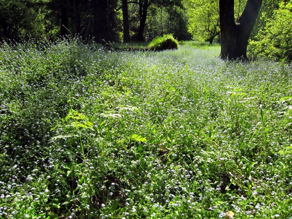
On the way down we passed this expansive field of Forget-me-nots. Some folks classify Forget-me-nots as undesirable, since they are an invasive species and tend to take over from the native species. However they are certainly striking in appearance. I'm told that Hulda McLean, who was Theodore Hoover's daughter and took care of the ranch before she died a couple of years ago, liked to sprinkle the seeds of this plant around. I don't feel too strongly about their presence. The photograph is another of Bob Schumacker's.
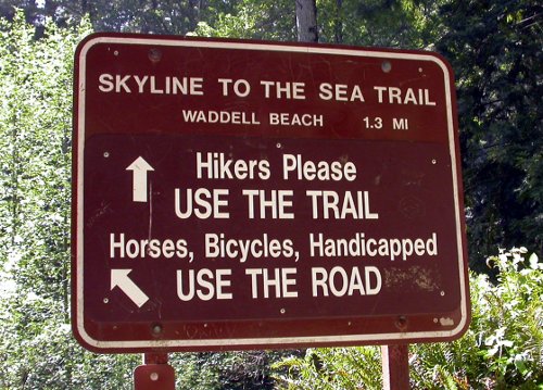
The last stretch involved a leisurely walk down to Highway 1 and the mouth of Waddell Creek where it empties in to the Pacific Ocean. After about an hour there are a pair of campgrounds—the Twin Redwoods Camp, and just a bit farther, the Alder Camp. Close to the Alder Camp, this sign indicates alternative routes and advises hikers to use the trail. Indeed the trail is preferable, since it climbs slightly up the west side of the canyon and affords a fine view of the ocean. The difference in distance between the two alternatives is small. However at the start of the trail is a bridge that is intended to span Waddell Creek, and early in the season that bridge might not yet be in place, or might (as we discovered on our walk) fall short of spanning the creek. In that case, the road alternative is the better one.
It ends with a bus ride
Eventually we reached the Ranger Station. From there on the road is paved. It's about a five-minute walk along that paved road to Highway 1, where we all arrived—shortly after 5:00 pm—just in time to board the No. 40 bus for the forty-minute scenic ride back to Pacific Avenue in Santa Cruz. Our bus driver was Jose—whom we thanked for the good service.
Acknowledgments
Many thanks to all who participated in this celebration of the anniversary of John Muir's birth. Muir was born in Dunbar, Scotland, on April 21, 1838. Those who participated in the celebration included Nancy Powell, DJ Goehring, Ginny Draper, Lynne Simpson, Jim Irving, Sandra Flores, David Garcia, Monique Fargus, Tom Moore, Deirdre Ryan, Giancarlo Thomae, Jim Ryan, Esperanza Hernandez, Allan Neymark, Brent Smith, Bob Schumacker, Nancy Alstrum, Nancy Howden and Maggie Dickson. In addition, thanks to those who contributed photographs for inclusion in this piece.
Finally, we are so fortunate for the existence of nearby parks and natural areas to walk in and explore, and especially for the public transportation service provided by our Santa Cruz Metropolitan Transit District that allows many such walks to be undertaken without the need for a private automobile.
— Peter Scott
Spring 2010
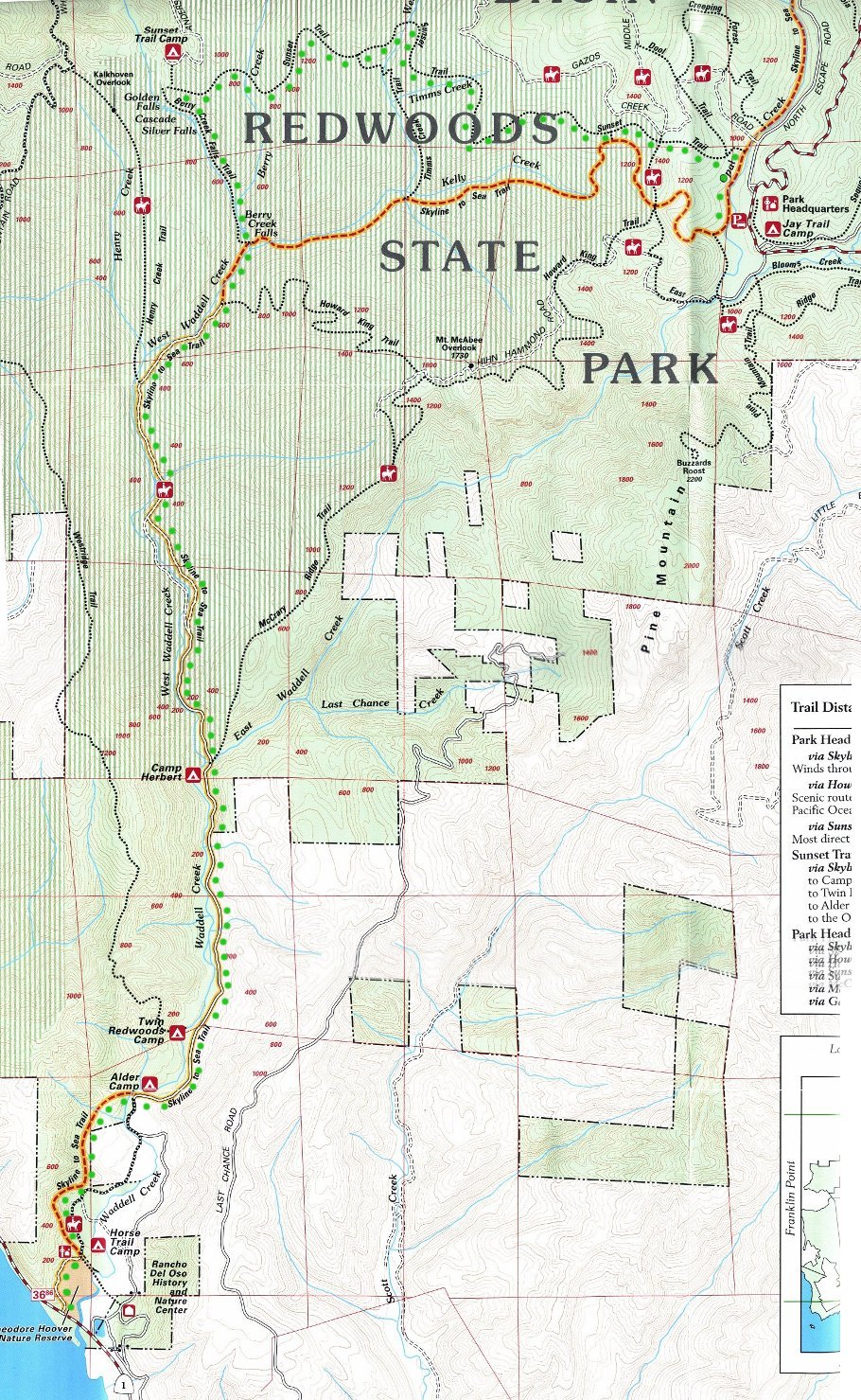
p.s. At the left is a thumbnail image of a map of our route. If you click on the thumbnail, a larger image of the map will be displayed. Our route is indicated by the line of green dots. There is also a pdf version of the map that is available here for downloading, in case you would like a printed version.